| a l a s k a j o u r n e y . c o m |
| Southcentral Mountains & Prince William Sound |
|
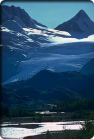
Road Conditions and Attractions—115 miles. Good, paved road open year-round with some tight turns and narrow lanes in the mountains. Mountain scenery, Worthington Glacier, Keystone Canyon, Copper Center. This first third of the Richardson begins in Valdez, climbs quickly to Thompson Pass in the Chugach Mountains, then drops gradually into the Copper River basin before reaching Glenallen and the south junction with the Glenn Highway. The drive takes about three hours at an easy pace with no stops. Old Valdez (Mile 0)—The official beginning of the Richardson is at the site of the original settlement of Valdez before the 1964 quake prompted its relocation. Keystone Canyon (approximately Mile 13 to Mile 16)—Stop for views of waterfalls and signs of the old trail. River runners enjoy the canyon. Blueberry Lake State Recreation Site (Mile 24.1)—Very nice campground with $10 sites. Thompson Pass (Mile 26, 2,678' elevation)—The highway crosses into the Copper River watershed, dropping down first along the Tsina River, then the Tiekel, Little Tonsina, and Tonsina Rivers. Reaching the basin, the route starts gradually uphill again as you parallel the Copper north to Glenallen.
Little Tonsina State Recreation Site (Mile 65.1)—Typical small campground with river access. Sites are $6. Bernard Creek Trailhead (Mile 78.9)—From here, the Bernard Creek Trail (15-plus miles, 1,600' gain) heads southeast along Bernard Creek and the former route of a telegraph line, and up into Kimball Pass with views and the possibility for further climbs. The BLM recommends this packed dirt route for mountain bikers. RT (mountain bike)—all day. Squirrel Creek State Recreation Site (Mile 79.6)—Campsites on the bank of the creek are $10. A store is next door. Edgerton Highway Junction (Mile 82.6)—Turn here to reach Chitina, McCarthy, Kennicott, and the heart of Wrangell–St. Elias National Park and Preserve. Pleasant Pippin Lake is across the road. Edgerton Highway Cutoff (Mile 91.1)—If you’re coming from the north and heading to Wrangell–St. Elias, take this 8-mile gravel cutoff—the Old Edgerton Highway—to hook up with the Edgerton. Copper Center Loop (Mile 100.2 and Mile 106)—Don’t miss this little detour onto a short loop of the Old Richardson Highway. The headquarters and visitor center for Wrangell–St. Elias National Park and Preserve is on the old road (See Copper Center, below). Klutina Lake Trailhead (Mile 101.5)—The Klutina Lake Trail (25 miles, 600' gain) is an old, rough road suitable for mountain bikes. The route follows the Klutina River through mainly forested country southwest to Klutina Lake. Consult with BLM officials or the Wrangell–St. Elias ranger in Copper Center. RT (mountain bike)—2 days. Glenallen (Mile 115)—See Glenallen. |