| a l a s k a j o u r n e y . c o m |
| The Kenai Peninsula |
|
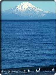
Road Conditions and Attractions—140 miles. Good, paved road open year-round. Kenai River watershed access, Kenai Mountain trailheads, Ninilchik, Homer, access to Kenai and coast. While the Seward Highway primarily features mountains, glaciers, and hiking, the Sterling is the road through fishing heaven. During the summer, and especially in June, campgrounds and accommodations along the Kenai River and other streams and lakes are jammed on weekends with salmon-fishing residents. Visit Kenai midweek or in the shoulder season—unless you wish to fish. Dropping quickly from the highway junction to the foot of Kenai Lake, the Sterling parallels the Kenai River all the way to the coast. Numerous campgrounds and river-access points line the route. At the town of Sterling, the road leaves the Kenai National Wildlife Refuge and enters the vacationland sprawl of the northwest Kenai coast. In Soldotna, the road heads southwest, regaining some charm as it reaches the Cook Inlet coast. Passing by historic Ninilchik, it swings east to Homer and road’s end. Milepost locations for the numerous campgrounds and recreation sites along this route are listed separately at the end of this section. Seward Highway Junction (Mile 37.7)—The Sterling Highway mileposts reflect the distance to Seward. Crescent Creek Trailhead (Mile 45)—See Kenai National Wildlife Refuge/Chugach National Forest Trails, above. Kenai Princess Lodge (Mile 47.7)—Cooper Landing, (800)426-0500, 595-1425. $230–$250 mid-June–August, $130–$150 shoulder seasons. Rustic luxury-tour hotel, all rooms overlook the Kenai River and mountains beyond, all amenities. Snug Harbor Road Junction (Mile 47.9)—This 12-mile road follows the west shore of Kenai Lake, providing access to Cooper Lake and Russian Lakes Trail as well as to lakeside fishing sites. (See Kenai National Wildlife Refuge/Chugach National Forest Trails, above, for details). Cooper Landing (Mile 48.4)—Businesses actually stretch for a couple of miles along this segment of road. Many residents of the largely non-native settlement of Cooper Landing (population 283, 1.2 percent native) work in fishing, tour, and travel services. Complete highway services are available. Russian Lakes Trailhead (Mile 52.6)—See Kenai National Wildlife Refuge/Chugach National Forest Trails, above. Resurrection Pass Trailhead (Mile 53.2)—See Kenai National Wildlife Refuge/Chugach National Forest Trails, above. Chugach National Forest/Kenai National Wildlife Refuge Boundary (Mile 54.7)—The highway enters the refuge here, trading the mountains for the lowlands at about the same time. Fuller Lakes Trailhead (Mile 57.1)—See Kenai National Wildlife Refuge/Chugach National Forest Trails, above. Skilak Lake Loop Road East Junction (Mile 58)—This 19-mile loop provides access to Skilak Lake and several campgrounds, and links up with the Sterling further west. There’s also a U.S. Fish and Wildlife Service information cabin here with data on regional public lands and opportunities. Skyline Trailhead (Mile 61.4)—See Kenai National Wildlife Refuge/Chugach National Forest Trails, above. Seven Lakes Trailhead (Mile 70.4)—The Seven Lakes Trail (6 miles, no gain) crosses forested and sometimes boggy flats between the Sterling Highway and Skilak Lake Road. As the name indicates, it passes seven lakes along the way. Through trail—half day. Skilak Lake Loop Road West Junction (Mile 75.2)—Turn here for Skilak Lake and several campgrounds. Kenai National Wildlife Refuge Boundary (Mile 76)—It will quickly be clear that you’re out of the protected area. Sterling (Mile 81)—From here through Soldotna and beyond is a human-habitation zone (see Northwest Kenai, below, for details). Swanson River Road Junction (Mile 83.4)—Head north for access to several lakes and the put-ins for outstanding long-distance canoe routes (see Swan Lake and Swanson River Canoe Trails, above, for details). Kenai Spur Highway Junction (Mile 94.2)—Turn here to reach Kenai, Nikiski, and Captain Cook State Recreation Area. Soldotna (Mile 95)—Plenty of services here. See Northwest Kenai. Kalifornsky Beach Road/Funny River Road Junction (Mile 96.1)—Turn west on Kalifornsky Beach Road, then take first right for the Soldotna Historical Society Museum and Visitor Information Center. Continue west for coastal access. Turn east on Funny River Road, then take first right for Kenai National Wildlife Refuge Visitor Center. Continue east for the Soldotna airport and access to south bank of Kenai River. Kenai National Wildlife Refuge Visitor Center (Mile 97.9)—Turn east on Ski Hill Road to reach the center. Kasilof and Kalifornsky Beach Road South Junction (Mile 108.8)—Coastal access, alternate route to Soldotna. See Northwest Kenai, below, for Kasilof information. Cohoe Loop Road North Junction (Mile 111)—Coastal access (see Sterling Highway Public Campgrounds and Northwest Kenai, below, for information on Cohoe and Crooked Creek State Recreation Area). Cohoe Loop Road South Junction (Mile 114.3)—See Mile 111. Clam Gulch (Mile 118.2)—The settlement of Clam Gulch (population 94, 12.7 percent native) is more location than town. Ninilchik Village Access (Mile 135.1)—Turn west here to reach the historic village (see below). Happy Valley (Mile 143.8)—This is actually the point where the Sterling crosses Happy Valley Creek, but the surrounding residences comprise the unincorporated settlement of Happy Valley (population 388, 6.1 percent native). Anchor Point (Mile 156.7)—Just north of town, you’ll pass the westernmost point of the North American highway network. Anchor Point (population 1,137, 3.7 percent native) is largely a residential satellite of Homer. Services are available. Homer (Mile 172.8)—See below. Homer Spit End (Mile 179.5)—Here, in the heart of Kachemak Bay, is road’s end. Stop in at the Land’s End Resort or the Salty Dawg Saloon for a well-earned refreshment. Sterling Highway Public Campgrounds and Recreation Sites Virtually all of the following campgrounds are on a lake or river, have potable water and restrooms, and are open to tents and small RVs. They are used primarily by fishers, boaters, canoeists, other watersports enthusiasts, and hunters—though travelers of every sort are welcome. Call 235-7024 (Homer office) or 262-5581 (Soldotna office) for state park information. Stern Lake National Forest Campground (Mile 37.4)—25 sites, $6. Quartz Lake National Forest Campground (Mile 45)—31 sites, $6. Crescent Creek National Forest Campground (Mile 45)—Nine sites, $6, 3 miles down Quartz Creek Road from Mile 45. Cooper Creek National Forest Campground (Mile 50.5)—26 sites, $6. Russian River National Forest Campground (Mile 52.6)—84 sites, $10, 2 miles down road from Mile 52.6. Skilak Lake Loop Road East Junction (Mile 58)—This 19-mile gravel road passes several campgrounds: Jim’s Land Campground (0.2 mile on Skilak Road)—five sites; Hidden Lake Campground (0.5 mile on Skilak Road)—44 sites, $6; Upper Skilak Lake Campground (8.5 miles on Skilak Road)—26 sites, $10, take spur road 2 miles along Ohmer Lake; Lower Skilak Lake Campground (13.8 miles on Skilak Road)—14 sites. Kelly and Peterson Lakes Turnoff (Mile 68.3)—Two three-site camp areas. Watson Lake Campground (Mile 71.3)—Three sites. Skilak Lake Loop Road West Junction (Mile 75.2)—See East Junction listings, above. Bing’s Landing State Recreation Site (Mile 80.3)—Turn here to reach riverside sites, $8. Isaak Walton State Recreation Site (Mile 82)—25 riverside sites, $10. Scout Lake State Recreation Site and Morgan Lake State Recreation Site (Mile 84.9)—Turn here to reach campgrounds via Scout Lake Loop Road, 64 total sites, $8 to $10. Centennial Park Campground (Mile 96.1)—Turn west 0.1 mile, 126 sites. Kasilof River State Recreation Site (Mile 109.4)—16 sites, $8. Johnson Lake State Recreation Area (Mile 110)—Go east and turn right at T to reach 50 sites, $10. Continue on Tustamena Lake Road 6 miles to Tustamena Lake Campground—10 sites. Crooked Creek State Recreation Site (Mile 111)—Go 2 miles west to campground. Clam Gulch State Recreation Area (Mile 117.4)—116 sites, $8. Ninilchik State Recreation Area (Mile 134.5)—Three small campgrounds located in the immediate vicinity, 43 sites, $10. Deep Creek State Recreation Area (Mile 137.3)—$10 sites. Stariski State Recreation Site (Mile 151.9)—13 sites, $10. Anchor River State Recreation Area (Mile 156.9)—Turn on Old Seward Highway and turn again to reach six campgrounds along Beach Access Road. Anchor River State Recreation Site (Mile 162)—Nine sites. |