| a l a s k a j o u r n e y . c o m |
| Anchorage, Matsu & Cook Inlet |
|
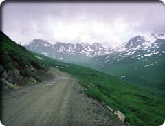
Most Alaska roads seem to cross over mountain passes reluctantly; Hatcher Pass Road seems to do it just for fun. Originally built as an access road to the mines in the Talkeetna Mountains, the road now offers travelers a route through high peaks and history. If you are driving and have four extra hours to spend on your way from Cook Inlet to Denali, opt for this wonderful alternative route. The crisp air and views at the top of the 3,886-foot pass are splendid. Most of the Talkeetna Mountains are state-owned land, and much of it is managed by the Department of Natural Resources (see the Appendix for contact information) in the Hatcher Pass Management Area. Along with thousands of undesignated acres, the area includes Independence Mine State Historic Park, Summit Lake State Recreation Site, and the proposed Hatcher Pass Ski Area. Also found in the area are the headwaters of the Little Susitna River, protected as the Little Susitna Recreation River—one of six designated state recreation rivers in the Susitna watershed. Quick visits to Hatcher Pass can include a drive with views, mining history, wildlife observation, and short roadside hikes. Experienced river runners can match their kayaking skills to the Class V whitewater of the “Little Su.” ( see the Appendix for outfitters.) Downhill and cross-country skiing are possibilities. Excellent longer trails and ridge routes allow access to the high country. Hatcher Pass is reached from Wasilla on Wasilla-Fishhook Road, from the Glenn Highway north of Palmer on Palmer-Fishhook Road, and from Willow on Willow-Fishhook Road. The pass is about 30 miles from Willow and about 20 miles from Palmer. Much of the road is gravel. It’s narrow and often slippery up high, with tight turns, steep grades, and limited maintenance (not recommended for RVs or the timid). Trails near Hatcher Pass Trails near Hatcher Pass include: Gold Mint Trail (7-plus miles, 1,000-plus-foot gain)—The trailhead is located where the road takes a sharp turn near Motherlode Lodge. The route follows the west bank of the Little Susitna River and climbs gradually through open country. The first miles are along the original trail to Lonesome Mine. The valley steepens into a cirque rimmed by small glaciers, including Mint Glacier below Montana Peak. Enjoy a relatively easy walk, valley views, isolation, and primitive camping. RT—all day. Reed Lakes Trail (3-plus miles, 1,600' gain)—Follow Archangel Road from Hatcher Pass Road to the Reed Lakes Trail trailhead. The trail follows Reed Creek as it winds into a high cirque with two small lakes. Primitive camping, beautiful alpine scenery. RT—5–7 hrs. |